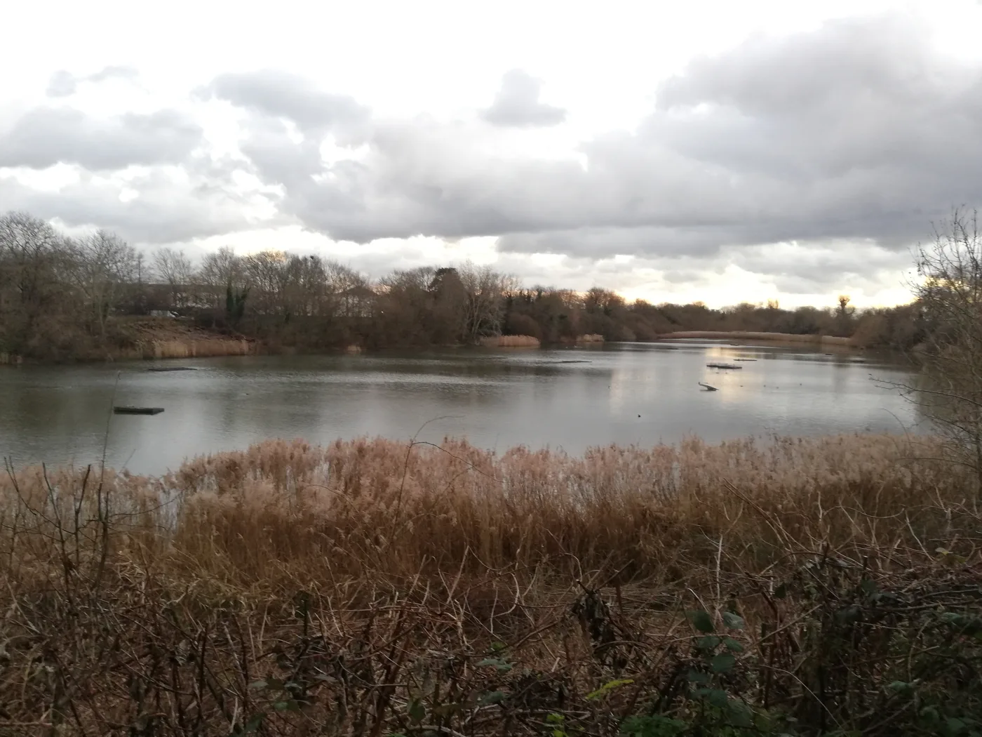

Storm water would be stored in the reservoir to cut tide-lock flooding. Ferry Lane closes for about two months, with the work due late 2026 to early 2027.
Richmond Council is being asked to approve a scheme that would divert storm water off the streets of north Barnes and into the Leg o’ Mutton nature reserve, to stop drains backing up when heavy rain meets a high tide on the Thames.
The decision goes to the council’s Environment, Sustainability, Culture and Sports Committee on 15 September. If it is approved, Ferry Lane would close for about two months while the work is done, and walkers would not be able to get all the way round the lake.
The work is proposed for late 2026 to early 2027, deliberately outside the bird nesting season.
The problem is a high tide, not a river bursting
The flooding this is meant to fix is not the Thames coming over the bank. It is what the council’s report to the committee calls tide lock.
The surface water sewer that drains rain off the surrounding roads discharges into the tidal Thames. At high tide it cannot discharge. Water then builds up inside a drainage system that was never designed to hold it. When heavy rainfall and a high tide land together, the report says, that build-up “can cause flooding in surrounding roads”.
The proposal is to give that water somewhere else to go. During heavy rain, flows would be diverted from the drainage network into the reservoir, which would hold them until the tide falls. A new fixed spillway would let the reservoir overflow back into the Thames in a controlled way.
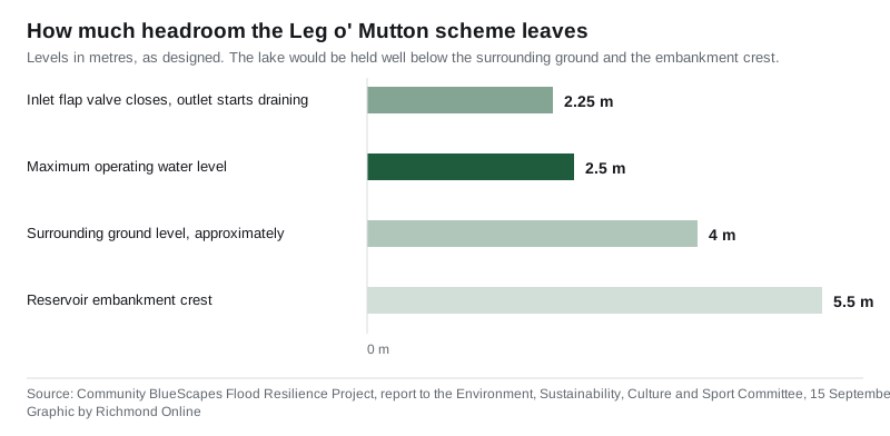
The lake would be held at a maximum operating level of about 2.5 metres, well below the surrounding ground at roughly 4 metres and the embankment crest at 5.5 metres. Above 2.25 metres the inlet flap valve is forced shut and the outlet starts draining the lake to the river. The council’s modelling says the reservoir can take the excess from a one-in-100-year storm during tide lock without exceeding its safety limits.
It is also meant to fix a lake that runs dry
The reservoir has a second, quieter problem, and the report is candid about it.
The only natural water reaching the lake is rain that falls on the site itself. In warm months, evaporation drops the level far enough to raise water temperatures and strip out oxygen, which hits fish, invertebrates and plants, and with them the food supply for the birds. It can also bring algal blooms.
The only way to top the lake up at present is to open a pipe to the Thames at high tide. That does three unwanted things at once, according to the report:
- it brings in brackish, salty water, unsuitable for a freshwater lake
- it introduces invasive zebra mussels, and protected European eels that then cannot get out again
- it brings in Thames sediment, which has built up to around 50cm on the lake bed
If the scheme does not go ahead, the report says plainly, the lake “will have ongoing water quantity and quality issues without a clear, viable or funded solution”.
The surface water would not go straight into the lake. The design puts it through a sediment capture chamber, a shallow settling pond and extensive reedbed filtration first, with flow controls that can send low flows, first-flush water or anything suspected of contamination directly to the Thames instead. The whole system can be isolated.
That treatment train exists because of what the testing found. Four sets of samples each of the surface water, the Thames supply and the reservoir itself were sent for laboratory analysis against Water Framework Directive standards. The surface water showed typical urban runoff, with occasional elevated concentrations of some metals compared with the Thames, though “generally low and below levels expected to cause acute ecological harm”. The conclusion was that untreated surface water should not be discharged to the reservoir, but that with treatment it could be used.
The Environment Agency wants to call the reservoir high risk
Separately from all of this, and unrelated to the scheme, the Environment Agency issued a designation review to the council in June 2026.
Leg o’ Mutton has been classed as “not high risk” since 2014, which means a reduced schedule of inspections under the Reservoirs Act 1975. The EA now proposes provisionally raising it to high risk, on updated modelling which suggests the reservoir could breach at its southern end.
One of the EA’s concerns, according to the report, is that the water level may previously have been kept deliberately low, and that there is no evidence the reservoir is physically incapable of filling to its registered top water level.
The council is pushing back. A Panel Reservoir Engineer is reviewing the EA’s modelling against up-to-date topography and is helping the council make a representation against the determination. The council also argues that the fixed spillway in this scheme would itself reduce the risk of the designation being changed.
What it means for you
The disruption is concentrated and it is worth knowing about in advance.
- Ferry Lane closes for roughly two months during construction.
- The paths around the lake stay open except the northern section, so you will not be able to walk round the lake.
- The council intends to keep the site entrance off Ferry Lane open, with the works boundary set back from it, subject to that being safe.
- An area of woodland and vegetation would be cleared to get the pipework in. Reinstatement is to be planned with the council’s parks department and the Leg o’ Mutton supporters group.
- Drop-in sessions, letter drops and on-site signage are promised before work starts.
The engineers, WSP, propose an open-cut trench with sheet piling along the boundary with the Swedish School. Directional drilling was the original preference, to avoid disturbing the site, but the Panel Reservoir Engineer instructed open cut so that ground conditions can be monitored and the embankment core properly reinstated when it is backfilled.
Only the northern surface water pipe would be disconnected. The southern pipe was judged too far from the lake to connect without cutting through established woodland, and access at the northern end is straightforward because it sits directly beside Ferry Lane.
The scheme still needs consent from Thames Water, because it involves work on Thames Water assets, and an application has gone in through the company’s developer services portal. The council does not need planning permission, because it is acting as a drainage body under the Land Drainage Act 1991, and the EA has confirmed no Flood Risk Activity Permit is required.
The money, and the deadline behind it
Development costs so far come to £156,191.63. Delivery is expected to cost up to £395,000, including detailed design.
Both are being met from Community BlueScapes, the council’s share of DEFRA’s Flood and Coastal Resilience Innovation Programme. Richmond secured £6 million over the period 1 April 2021 to 31 March 2027, as one of 25 projects nationally, and works in partnership on it with Barnes Common Limited and WWT, formerly the Wildfowl and Wetlands Trust. The programme covers the Beverley Brook catchment: Barnes, Castelnau, East Sheen and Mortlake.
That end date is the pressure point. The report states that if the project cannot be delivered before March 2027, “an alternative funding source will have to be found”.
The reserve itself
The reservoir was built in 1838 and supplied water until it was decommissioned in 1960. The council bought 8.2 hectares of the site from Thames Water in 1970 and turned it into a nature reserve, on the suggestion of residents. It was designated a Local Nature Reserve in 1990 and registered as a Site of Borough Importance for Nature Conservation in 1993.
The report lists what lives there: teal and shoveler in winter, breeding pochard and little grebe, reed and Cetti’s warblers, the occasional water rail, common terns nesting on the rafts, an active heronry and increasingly frequent little egret. Stag beetle, oak bush cricket and speckled wood butterflies are among the invertebrates recorded.
The papers are on the committee’s agenda page, and the meeting is at 7pm on 15 September. Current road closures across the borough, including the gas works running through Barnes until late November, are on our Richmond roadworks and travel page.
Sources
- Community BlueScapes Flood Resilience Project, report of the Executive Director of Growth and Place to the Environment, Sustainability, Culture and Sport Committee, London Borough of Richmond upon Thames, 15 September 2026, for the tide-lock explanation, the design levels, the water quality testing, the construction method, the Ferry Lane closure, the woodland clearance, the Environment Agency designation review, the costs and the site’s history and wildlife.
- Environment, Sustainability, Culture and Sports Committee, 15 September 2026, London Borough of Richmond upon Thames, for the agenda and meeting time.
- Community BlueScapes project website, named in the report as the programme’s public information source.
Have your say